Student Support Services
Directions to WKU Student Support Services
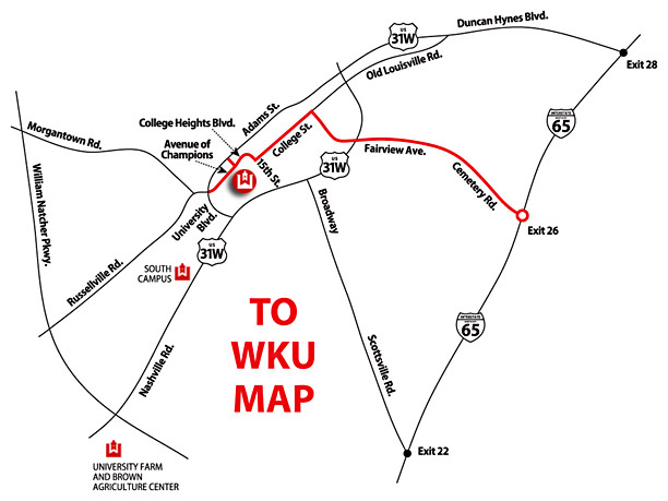
DIRECTIONS FROM NORTH AND SOUTH I-65
- Take Exit 26 off of Interstate 65.
- Turn toward Bowling Green onto Cemetery Road.
- Continue straight for three miles. Cemetery Road becomes Fairview Avenue. Continue going straight across 31-W Bypass. You will pass a fire station on your left. After passing the fire station, go through one traffic light and a stop sign, then turn left at the second stop sign onto College Street (this is a one-way street).
- Stay on College Street through downtown Bowling Green and continue until you reach the top of the hill. College Street will dead-end at College Heights Boulevard at a statue of Henry Hardin Cherry. Turn right onto College Heights Boulevard.
- Follow College Heights Boulevard all the way to the end and get into the lane to turn left at the stop light. Turn left on University Boulevard. You will see Jones Jaggers Hall, a round building to your right.
IF YOU ARE TRAVELING ON THE WILLIAM NATCHER PARKWAY (from Owensboro):
- Take exit #5 off the William Natcher Parkway for US-68.
- Turn left off the exit ramp.
- You will travel approximately 2 miles, go under a train trestle, and come to a stop light at University Boulevard.
- Turn right on University Boulevard. You will see Jones Jaggers Hall, a round building to your right.
More detailed parking maps are available on the Parking and Transportation website.
Some of the links on this page may require additional software to view.