Waterfront Redevelopment and the Puerto Madero
Project in Buenos Aires, Argentina
David J. Keeling
Department of Geography and Geology
Western Kentucky University
Bowling Green, KY 42101-3576
USA
Tel: 1-270-745-4555
Fax: 1-270-745-6410
Email: david.keeling@wku.edu
Abstract
Landscape
changes in the world’s major cities can be indicative of participation in and
engagement with the forces of globalization.
Although such changes are of great interest to geographers, who read and
analyze urban landscapes to interpret influences, meaning, social implications,
and identity, they are also very significant for others. Perceptions and impressions of a city formed
or created by business people, city boosters, tourists, residents, and
governments often are derived from the built landscape; transport
infrastructure, innovative buildings, open spaces, cultural facilities, and
physical attributes all contribute to how we “see” a city. Competition among cities to attract international
investment is fierce, and governments are learning that innovation and
creativity in infrastructural development are critical to gaining world-city
status and thus a share of the global economic potential.
Buenos Aires, Argentina, is an excellent exemplar of
urban landscape change in Latin America driven by conditions of
globalization. This paper examines the
Puerto Madero redevelopment project as indicative of the city's landscape
restructuring policies. Through a
detailed landscape and policy analysis, the strategies and implications of the
project are discussed and the role of globalization in driving the project is
critiqued. The paper concludes with an
analysis of the project's weaknesses and the broader implications for landscape
restructuring in this and other cities around the world.
Resumen
Los cambios del paisaje en las ciudades principales del mundo pueden ser indicativos de la participación en y del contrato con las fuerzas de la globalización. Aunque tales cambios están de gran interés a los geógrafos, que leen y analizan paisajes urbanos para interpretar las influencias, los sentidos, las implicaciones sociales, y la identidad, son también muy significativas para otras. Las opiniones y las impresiones de una ciudad formada o creada por la gente del negocio, los promotores de la ciudad, los turistas, los residentes, y los gobiernos se derivan a menudo del paisaje construido; la infraestructura de transporte, los edificios innovadores, los espacios abiertos, los recursos culturales, y los atributos todos contribuyen a cómo "vemos" una ciudad. La competición entre ciudades de atraer la inversión internacional es feroz, y los gobiernos están aprendiendo que la innovación y la creatividad en el desarrollo infraestructural son críticas a ganar estatus de la ciudad mundial y así una parte de la empanada financiera global.
Buenos Aires, la
Argentina, es un ejemplo excelente del cambio urbano del paisaje en América
Latina conducida por las condiciones de la globalización. Esta ponencia examina el proyecto de Puerto
Madero como indicar de las políticas de la reestructuración del paisaje de la
ciudad. Con un análisis detallado del paisaje y de política, las estrategias y
las implicaciones del proyecto se discuten y el papel de la globalización en
conducir el proyecto es criticado. La
ponencia concluye con un análisis de las debilidades del proyecto y de las
implicaciones más amplias para el paisaje que reestructura en esto y otras
ciudades alrededor del mundo.
Waterfront
Redevelopment and the Puerto Madero
Project in
Buenos Aires, Argentina
Introduction
Waterfront
redevelopment has emerged in recent decades as a central element in the
revitalization of urban areas.
Settlements with any kind of water frontage, whether it is on a river,
canal, lake, estuary, or ocean, are exploring ways to take advantage of the
environmental and aesthetic appeal of waterfront activities within the broader
context of urban renewal. The impetus for waterfront redevelopment is embedded
in the political, economic, social, and environmental forces that are
encouraging city governments to rethink the functionality and purpose of the
urban landscape. In addition, significant landscape changes are occurring as
cities participate in, and engage with, the processes of economic
globalization.
Although
such changes are of great interest to geographers, who read and analyze urban
landscapes to interpret influences, meaning, social implications, and identity,
they are also very significant for others.
Perceptions and impressions of a city formed or created by
businesspeople, city boosters, tourists, residents, and govern-ments often are
derived from the built landscape. Transport infrastructure, innovative
buildings, open spaces, cultural facilities, and physical attributes all
contribute to how we “see” and "experience" an urban
environment. Competition among cities
to attract international investment is fierce, and governments are learning
that innovation and creativity in infrastructural development are critical to
gaining world-city status and thus a share of the global economic potential.
Buenos Aires, Argentina, is an excellent exemplar of
urban landscape change in Latin America driven by conditions of globalization.
With the emergence of globalization both as an ideology and as a process in
Argentina beginning in the late 1980s, attention began to turn towards more
integrative urban planning and to development strategies designed to attract
international capital and capitalists.
The problem of addressing the city's run-down port area, known as Puerto
Madero, entered the local urban revitalization debate and emerged as a viable
rehabilitation project. This essay examines the Puerto Madero redevelopment
project as indicative of the city's landscape restructuring policies. Through
an analysis of the landscape and of the policies directed toward urban renewal,
the strategies and implications of the project are discussed and the role of
globalization in driving the project is critiqued. The essay concludes with an analysis of the project's strengths
and weaknesses and of the broader implications for landscape restructuring in
this and other cities around the world.
Globalization and Urban Landscape
Change
From a
theoretical perspective, globalization can be interpreted as the intersection
of the spaces of production (fordist or modernist functions), consumption
(postmodernist functions), and manipulation (global command and control
functions). New urban infrastructure is
created at the intersection of these three spaces, and waterfront redevelopment
is just one manifestation of this process.
Infrastructure is the visible expression of global and national capital
"touching down" on the local landscape to help create the conditions
that restructure the spaces of production, consumption, and manipulation. It is hypothesized that the nature of a
city's integration with the global economy is highly correlated with the degree
of infrastructural investment and development. Measuring such things as the
strength of engagement with the global economy, relative command and control
power, the degree of spatial influence, or the significance of new
infrastructure, for example, can provide important empirical evidence about the
processes of globalization and world-city development (Taylor et al.
2001).
Cities
that aspire to "global" status or that desire to participate more
profitably in the globalization process view new infrastructure as
critical. Integrated transport
services, quality educational facilities, cultural iconography, visually
stunning buildings, public spaces, and rehabilitated waterfronts, et cetera,
all are elements of the urban cultural landscape that reflect the strength of a
city's global engagement. Moreover,
infrastructure makes a visual statement about a city -- it can be a powerful
tool in creating and promoting an image of "globalization." For example, Sydney's international exposure
through hosting the 2000 Olympic Games derived in part from new infrastructure
built for the event, as well as from the existing cultural landscapes (Opera
House and Harbor Bridge) that stand out as symbolic of Sydney's status as a
"world city." Other cities
such as Seoul, Shanghai, Hong Kong, Kuala Lumpur, Tokyo, London, San Francisco,
São Paulo, and Buenos Aires have constructed buildings and facilities that
provide powerful visual evidence of engagement with globalization; for example,
the Docklands Light Railway, Petronas Towers,
Oriental Pearl Tower, the Tsing Ma Bridge, et cetera (Cybriwsky 1998; Ford 1998; Foster 1999; Keeling 1999; Kim
and Choe 1997).
Changes in
infrastructure, global trade linkages, urban land-use practices, and planning
policies all influence urban design, functionality, and aesthetic appeal. From an analytical perspective, two broad
frameworks for understanding urban landscape changes have developed since the
1980s (Fainstein 1996, Keeling 1999). At the global level, urban environments
are situated along a continuum of regional, national, and international systems
and researchers have analyzed such themes as uneven development, social
polarization, and competitive economic advantage within these systems. Soja’s
(1997) discourse on the contemporary city, or postmetropolis, for instance,
proposed the concept of “cosmopolis” to encompass the globalization of urban
capital, labor, and culture and the formation of a restructured hierarchy of
global cities. The urban impacts of
globalization are varied, complex, and have stimulated a "shift in the
attitudes of urban governments from a managerial approach to
entrepreneurialism" (Habitat 2001:26). The role played by global cities as
key economic command and control centers within the contemporary world-system
has encouraged much exciting research under the umbrella of world-city theory
(Friedmann 1986; Hall 1966; Knox and Taylor 1995). For example, examinations of Latin American cities such as Buenos
Aires (Keeling 1996, Torres 2001), Mexico City (Pick and Butler 1997; Ward
1998), and Havana (Segre et al. 1997) have drawn explicitly and implicitly on
the world city concept to explicate the relationship between local urban change
and global macroeconomic forces.
Research
on urban restructuring at the local scale explores the processes shaping the
essential character of a city from “the inside out” (Fainstein1996:170). Local actors, institutions, community
structures, labor divisions, levels of accessibility, cultural iconography, and
economic activities all drive urban restructuring in specific and mutually
reinforcing ways. The aim of this “view from below” theoretically is to mesh
the macro-level structuring of the city with, in Soja's (1997:21) words, the
“micro-worlds of everyday life” in order to understand more clearly spatial
changes in the urban fabric. Ford's (1998) analysis of world cities, for example,
highlights the dynamism and modernity of so-called "midtowns" and
"megastructures" and the role they play in the global identity of a
city. At the other end of the urban spectrum, Jakle and Wilson (1992) have
explored the problem of derelict landscapes in cities and the social and
economic problems they generate. Hoyle (2000:413) has examined specifically the
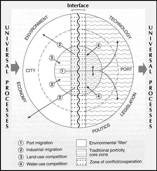
changing nature of ports and waterfronts, focusing specific attention on the
intertwining of "universal processes [...] [with] individual locations and
environments" (Figure 1). The characteristics of this interface include
external or universal processes that both shape and are shaped by the
environmental, political, technological, economic, and legislative forces that
mediate port-city interaction.
In cities
as diverse as Liverpool and Marseilles, London and Sydney, or Baltimore and
Buenos Aires, waterfronts are emerging as new centers of social and economic
activity (Breen and Rigby 1996). Once
run-down and derelict urban land-scapes are being reborn as attractive areas
hosting retail and sporting facilities, as well as offices, hotels, educational
centers, and other specialty services.
Throughout the 20th century, and particularly in the post-World War Two
period (1950s to 1970s), the restructuring of the shipping industry
(containerization) accelerated the demise or deterioration of once-thriving
waterfronts. Port cities especially
faced the reality of abandoned warehouses, unproductive real estate often in
prime locations, decaying industrial landscapes, and unattractive and badly
polluted physical environments. Since the 1980s, however, changes in maritime
technologies and a renewed focus on urban renewal strategies stimulated, in
part, by globalization ideologies and processes have encouraged waterfront
revitalization projects. These projects have generated a significant body of
literature in the disciplines of urban planning, politics, environmental
management, cultural ecology, and geography (Hall 1993, Hoyle 2000).
As Hoyle
(2000:415) posited, the potential of waterfront redevelopment depends on three
things: "First, integration of past and present; second, integration of
contrasting aims and objectives; and third, integration of communities and
localities involved." This
approach to understanding the characteristics and implications of waterfront
revitalization can be applied to the Puerto Madero project in Buenos Aires,
Argentina. Between the 1920s and 1980s
a wide swath of the city's river frontage deteriorated progressively, to the
point where several hectares between the central city and the Río de la Plata
formerly occupied by the Madero port operations had become an eyesore,
frequented by urban squatters and transients and in serious decay. As the government of Argentina began to
embrace the ideologies of globalization at the end of the 1980s, it focused
renewed attention on both the role and the image of Buenos Aires in the global
system (Keeling 1996). Puerto Madero
particularly stood out as a symbol of failed urban renewal policies and as a
symptom of much that was wrong with the city's development ambitions. In
November 1989, presidential decree 1279/89 created the "Former Puerto
Madero Corporation" and charged it with developing a Master Plan for Urban
Development to revitalize the 170-hectare site. As Carlos Corach (1999:13), former Minister of the Interior,
observed, the Puerto Madero project is "much more than real-estate
development; it is the new plan that defines the future city. It is the road to follow to achieve a
destiny of progress and it is the new configuration of urban space that
emphasizes the public good."
Historical Puerto Madero
Internal
political struggles between Buenos Aires and the rest of Argentina following
independence in 1816 stymied the construction of a major port in the city. Not until the political compromise of 1880,
when the city of Buenos Aires became the +federal capital of Argentina, did
work commence on a modern port facility located in front of the city along the
Rio de la Plata shoreline (Scobie 1971).
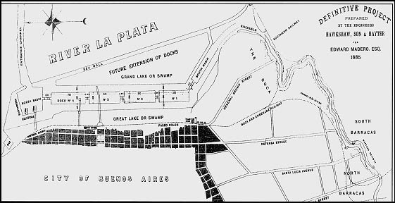
In 1881, engineers Eduardo Madero and John Hawkshaw proposed the
construction of two major channels, one to the south and the other to the north
of the main river channel, with two docks at the entrance of each channel. A series of parallel interconnected quays
would be located directly south of the Plaza de Mayo (the city center) and
would allow for significant expansion to the north of the central city (Figure
2).
Construction
began in 1887, with the port opening formally on January 28, 1889, and the four
parallel quays were inaugurated between 1890 and 1897. The development of
Puerto Madero ended three decades of political conflict, competing interests,
and unfulfilled potential for the city, allowing for significant expansion in shipping
operations. However, technical and operational problems with the port became
evident almost immediately, highlighting the lack of long-term planning and a
complete misunderstanding of the spatial dynamics of port operations. The facilities were totally inadequate for
loading and unloading, access and egress proved complicated, the channels could
not accommodate the rapid growth in vessel size, and the warehouses were
unsuitable for the types of goods being shipped. In 1919, construction on a new port began to the north of Puerto
Madero, and by 1925 the Madero facilities had fallen idle (D'Angelo 1963).
Various
rehabilitation projects were proposed over the next sixty years, starting with
the Organic Plan for Municipal Urbanization formulated between 1923 and 1935
and culminating in 1985 with a study of the area by the School of Architecture
at the University of Buenos Aires in partnership with the Secretary of State
and Transport. The eminent French urban
planner Le Corbusier (1947) recommended after a 1929 visit to Buenos Aires that
only strong and enforceable land-use and development laws could rescue Puerto
Madero from decay. His plan called for
the restoration of the riverfront as a symbol of the city's future and for the
construction of an artificial island -- the Cité des Affairs -- with five
skyscrapers. Unfortunately, political
crises, administrative jealousies, and the lack of a metropolitan development
strategy stymied any attempt at rehabilitating the port area. As a consequence of this inaction, the
administrative and commercial functions of the city spread northwards away from
the Plaza de Mayo-Puerto Madero axis and the historic central-city
neighborhoods of San Telmo, Monserrat, Barracas, and La Boca also fell into
decline. Buenos Aires had become a city
with its back to the river.
Contemporary Puerto Madero
Changing
national and international political and economic circumstances in the late
1980s encouraged a re-evaluation of the role of both Buenos Aires and Argentina
in the global economy. With the
election in 1989 of President Carlos Menem, a dramatic shift occurred in
Argentina's planning and development ideologies. Menem abandoned the traditional ideologies of the Peronist
political party (dirigismo or significant state intervention in the
economy and society) and turned the country toward neoliberalism and
globalization. Over the next few years,
so-called "structural adjustment" programs opened up the national
economy to global competition, privatized nearly all public services,
liberalized the financial and capital markets, and pegged the national currency
to the U.S. dollar on a one-for-one basis. Menem declared that Argentina now
belonged to a "single world ... a new juridical, political, social, and
economic order" (Gills and Rocamora 1992:515). Moreover, he argued that Buenos Aires, the national capital and
center of Argentine life, should play a central role in the country's
globalization strategies as a world city, an international gateway, and a key
economic center in South America.
As this
new ideology began to pervade the political and business arenas, both the mayor
of Buenos Aires and the president of the city's Urban Planning Council saw an
opportunity to revive the Puerto Madero redevelopment project. They realized,
however, that significant private investment, both local and international,
would be needed if the project were to have any chance of success. After intense negotiations between city and
federal government officials, the Corporación Antiguo Puerto Madero was
created in November 1989 and a redevelopment master plan was formulated in
cooperation with the Municipality of Barcelona, Spain. Barcelona had recently
completed a significant restoration of its own port environment and experts
from that project provided the Buenos Aires management team with ideas and
strategies for the Puerto Madero rehabilitation. The resulting master plan called for the construction of three
million square meters of covered space on 170 hectares of land, with a total
investment of 1.5 billion dollars.
With the
creation of a public-private partnership system designed to represent the many
competing political and economic interests, the next step involved untangling
the multiple jurisdictions that controlled property in Puerto Madero and
creating a mechanism to finance the redevelopment. Several provincial, federal, and municipal agencies, as well as
private corporations doing business in the area, used the docks, old
warehouses, and mills, as did hundreds of illegal squatters. To solve the
jurisdictional and financial problems, the federal government transferred
ownership of the land and the existing infrastructure to the newly established
corporation and required that the property be used to raise capital solely for
the redevelopment of Puerto Madero. Resolution of these problems marked the
first time in the urban planning history of Buenos Aires that the federal
government and the municipality had reached an agreement on a joint urban
development policy, especially one that would have such far-reaching
implications for the city.
When the
Barcelona experts delivered their strategic plan for the redevelopment of
Puerto Madero to the mayor of Buenos Aires in July 1990, protests erupted over
the lack of local participation in the project. Pressure from the Central Society of Architects, the Center of
Professional Architects and Planners, and other groups in Buenos Aires forced
the Corporation to establish the National Contest of Ideas for Puerto Madero. Design submissions were required to
demonstrate how Puerto Madero could be rescued from its deteriorated state and
reincorporated into the central city.
Moreover, residential areas had to be integrated with existing tertiary
uses, open green spaces had to be doubled, and recreational and cultural
activities had to be accommodated. The
final condition of the contest required that the historical heritage of the
site be included in the project design. Ninety-six submissions were received and
in February 1992 a panel of judges selected three winning teams, with three
representatives from each winning team responsible for developing the final
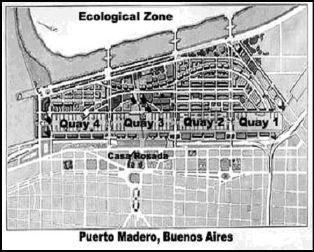
plan. In October 1992, the Corporation
unveiled the preliminary urban plan for the redevelopment of Puerto Madero,
which included a proposal to establish a cluster of residential towers and
office buildings at the edge of the project to mark the city's new limits on
the Río de la Plata (Figure 3).
Earlier in
1991, the Buenos Aires City Council had passed legislation designating the area
that included the docks, wharves, and warehouses fronting avenues Madero and
Huergo as the "Former Puerto Madero Area of Heritage
Protection." Conservation of the
sixteen red-brick warehouses that stretched 2.5 km along the western side of
the docks thus became a priority for the Corporation. The warehouses were
designed in England, shipped to Argentina in sections, and assembled in place
between 1900 and 1905. With covered
verandahs, platforms facing the water, and cranes attached to the walls, the
buildings were outstanding examples of 19th-century English industrial
architecture and the government considered them of significant cultural and
historic value. With a stipulation that
the external façades remain, the first five warehouses located on the north side
of the docks near the Retiro transportation complex were sold by public tender
in late 1991. The sale raised
approximately 20 million dollars for the Corporation, with a further 45 million
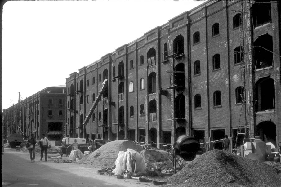
dollars pledged as investment in the rehabilitation of the warehouses. Construction began in September 1992 with
the gutting of the warehouse interiors (Figure 4) and restaurants, bars, and
office suites soon began to emerge from the rubble (Figure 5). Sale of the remaining warehouses occurred in
late 1992, with ten million dollars raised for the Corporation and the promise
of a further 40 million dollars in renovation investment. Especially important for the mixed-use
strategy of the development was the awarding of four warehouses on Quay 2 to
the Argentine Catholic University for its new city campus.
As the
warehouses metamorphosed into new commercial outlets, apartments, and office
space, work began on the two towers that serve as "gateways" to the
northern (Telecom Building) and southern (Malecón Building) ends of the
project. In addition, work began on
repairing the sidewalks, esplanades, bridges, and access roads that connected
the various areas of Puerto Madero. The
influx of new businesses and people to Puerto Madero had immediate positive
impacts on the Catalinas Norte office complex located at the northern end of
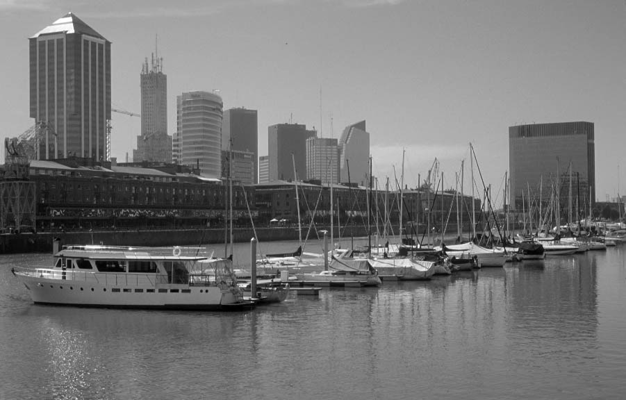
the project in front of the Retiro transportation center (Figure 6). New
buildings sprang up as the area quickly emerged as the premier office center in
Buenos Aires. At the southern end of
Puerto Madero, completion of the La Plata freeway connection, construction of
the "intelligent" Malecón office tower, the development of the
university campus, and the opening of a state-of-the-art cinema complex on quay
one signaled the potential redevelopment of the adjacent San Telmo, Barracas,
and La Boca barrios. These
neighborhoods had deteriorated significantly since the 1940s and 1950s, when
the development thrust of the central city had turned to the north and west,
away from the river and away from the historic southern quarter.
By 1997,
most of the redevelopment work on the western side of Puerto Madero had been
completed and attention now turned to the eastern side of the quays. In keeping
with the mixed-use strategy adopted by the Corporation, construction began on
hotels, office buildings, apartment towers, parks, a parish church, new
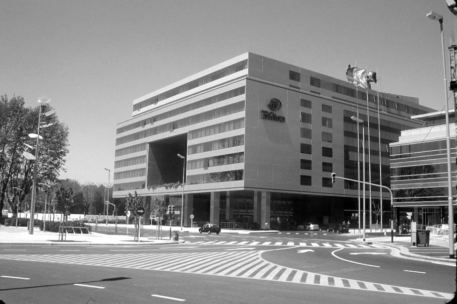
museums, another cinema complex, and a conference center. Anchoring the central part of the project
is the five-star Hilton Hotel (Figure 7), with a 4000-square meter convention
center, surrounded by office buildings and apartment complexes. To the south,
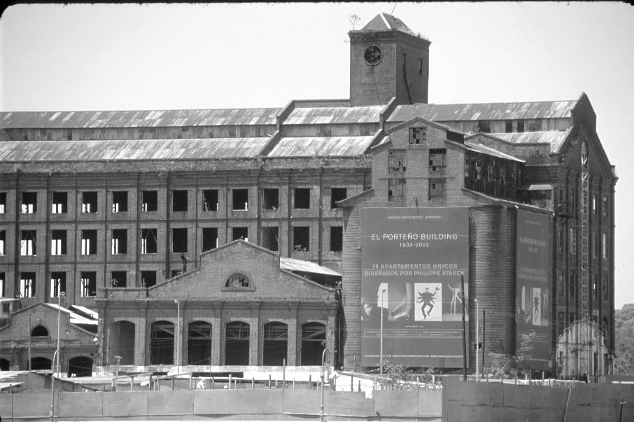
three industrial buildings of historical significance to the city will be
preserved and renovated: the Di Tella Foundation is converting the flour mill
at quay 3 into a series of university research institutes; the El Porteño mill
on quay 2 is to become a luxury hotel remodeled by French designer Philippe
Starck (Figure 8); and the large grain elevator on quay 3 will be merged into
the Madero Este project (Figure 9).
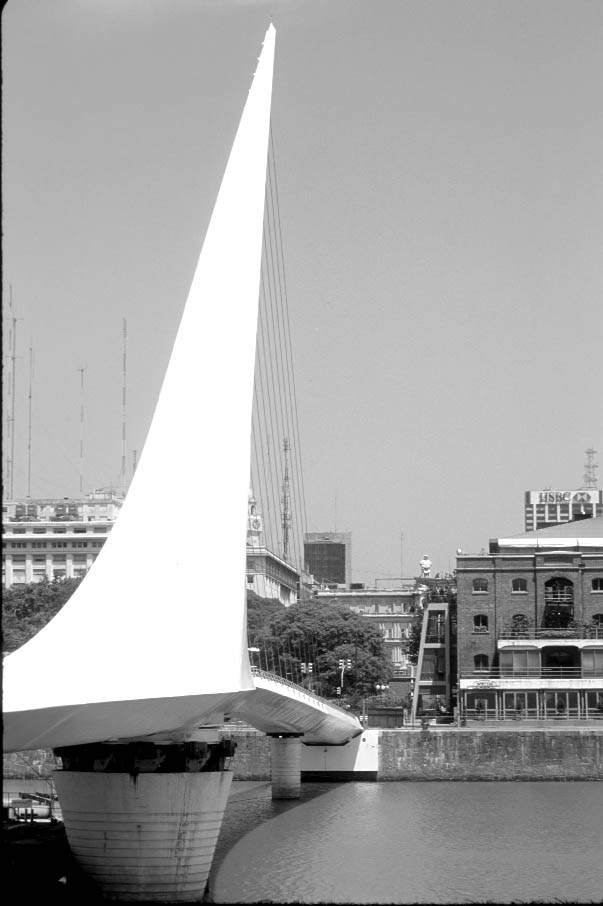
Finally, to link this central area of Puerto Madero, especially the
Hilton Hotel and its surrounding offices and apart-ments, to the city center, a
swinging pedestrian footbridge has been constructed across quay 3 (Figure 10).
Other projects designed to increase the aesthetic and
touristic appeal of Puerto Madero included the relocation of two museum ships
to quays one and two respectively and the development of large public
spaces. All of the streets and parks within
the redevelopment zone have been renamed after women who have made cultural and
humanitarian contributions to Argentina. Sculptures have been erected at key
inter-sections, trees and benches are located along the main esplanades and
also at key intersections, and information boards in Spanish, English, and
Portuguese are placed strategically around the entire area. Upwards of 100 million dollars also have
been invested in basic service infrastructure such as power and water lines,
sewer systems, data and voice lines, rehabilitated bridges, and street
signage. In recognition of the
significant metamorphosis of this once-derelict area, the city government
incorporated Puerto Madero on September 9, 1998, as the official 47th
barrio of the Autonomous City of Buenos Aires.
As of November 2001, the original
170-hectare site is divided between three specific uses: the quays and other
waterways cover 39.5 hectares, public spaces account for 69.1 hectares, and the
remaining 61.4 hectares have been urbanized or designated for residential or
commercial use. Construction remained
active on fourteen different projects within the zone, with total private
investment in completed projects and in works-in-progress exceeding two billion
dollars. However, the political and
economic collapse experienced by Argentina in December 2001 has cast a dark
cloud over the entire Puerto Madero project, particularly in light of the
abandonment of the Convertibility Law that has spurred a rapid devaluation of
the Argentine peso relative to the US dollar.
Project Evaluation
and the Future of Puerto Madero
In terms of the original goals of
the governments, planners, business interests, and institutions involved in the
Puerto Madero project, the overall redevelopment of the area has been a
resounding success. Jurisdictional
conflicts were overcome, the lack of public funding did not stymie private
investment, the entire zone has been physically and aesthetically rejuvenated,
thousands of people daily flow through the area, and the city indeed has turned
its face back towards the Río de la Plata.
Moreover, the redevelopment of Puerto Madero has encouraged new public
and private investment in riverfront areas to the north and south of the
project, although not at the level enjoyed by Puerto Madero. Although there have been complaints about
corruption throughout the twelve years of the project, as well as charges of
mismanagement of Corporation funds, public attitudes about the area and its
facilities on balance have been generally positive.
Referring
back to Hoyle's (2000) three keys to potential waterfront redevelopment, the
Puerto Madero project certainly achieved the first objective of integrating the
past and present. The turn-of-the-century warehouses, in particular, serve as
functional, aesthetic, and historical anchors for the project. Integration of contrasting aims and
objectives into the project design, the second objective, has been less
successful, although a balance has been achieved in Puerto Madero between
public and private needs and uses.
Achievement of the final objective, integration of communities and
localities involved, is still subject to substantial debate, as some significant development issues remain unresolved.
Puerto Madero still is poorly served by public transport and
is not well integrated with the urban transit network. Access and egress to the zone by pedestrians
remain difficult and dangerous, especially across the two major boulevards that
separate Puerto Madero from the city center. Buenos Aires also lacks any
sophistication in its tourism marketing and promotion vis-a-vis the new area,
and there is little evidence that Puerto Madero’s attractions have been
meaningfully articulated with the city’s major tourist destinations. Plans for the connection of the La Plata
freeway in the south to the northern freeway remain in limbo. The Corporation
is opposed to either a ground-level or elevated freeway that would pass in
front of the rehabilitated warehouses, arguing that such a plan would create
both physical and aesthetic problems and inhibit further growth in Puerto
Madero. A proposal to bury the freeway
link in a tunnel underneath Madero and Huergo avenues is on the drawing board,
but the costs of such a project, especially in light of the nation’s bankruptcy
in early 2002, remain prohibitive. A
third proposal to extend the freeway link across the ecological zone that lies
between the new development and the Río de la Plata has met with vociferous
resistance by planners and environmentalists.
Although a railroad line runs parallel to Puerto Madero, providing a
rush-hour passenger service from the western suburbs, the infrastructure is in
very poor repair and needs significant investment in new track, signaling, and
rolling stock.
Criticism has been leveled against
the project by community action groups and others who have argued that the
funds generated by the sale of public land in Puerto Madero could have been
better invested in social welfare projects elsewhere in the city. Critics complain that Puerto Madero has
achieved its goal of creating an urban landscape worthy of globalization and
world-city status all too well, effectively excluding the masses of Buenos
Aires from engaging with the project in any meaningful way. The rehabilitation of Puerto Madero has
articulated Buenos Aires and Argentina more forcefully with the global economy
and its circuits of international capital, yet it has disarticulated the area
from the basic socio-economic rhythms of the city. In light of Argentina’s economic crisis at the beginning of 2002,
the Puerto Madero project may reveal a significant vulnerability to its
dependence on global capital and the trans-national elite. Will there exist sufficient financial
stimuli to see the remaining development through to completion, or will much of
Puerto Madero stagnate once again and become a huge, unfinished construction
zone? Moreover, is there sufficient
demand in the local, national, regional, and global economies to sustain the
businesses already committed to the area?
Bankruptcies and failures rippling through the Argentine economy may
well wreak havoc on Puerto Madero in the months and years ahead.
Returning to Hoyle’s (2000) characteristics of the
port-city-global interface (see Figure 1), it is evident from examining the
Puerto Madero experience that universal processes played a critical role in the
redevelopment of this landscape. It is
unlikely that port redevelopment projects of any significant size around the
world could succeed today without serious engagement with global capital and
international management. However, in
less-robust economies this global engagement could well signify an increased
level of project vulnerability and a lower certainty of long-term success. Building new and rehabilitated
infrastructure may be a prerequisite for increased global engagement and world
city activities, but it may also prove to be a serious economic burden that
could accelerate the collapse of a weakening domestic economy. Should this happen in Buenos Aires, the city
might face renewed conflict over land-use planning and development strategies
and could be forced to rethink the level of its engagement with globalization
and world-city strategies.
Acknowledgments
A version of this paper was
presented at the 2001 CLAG conference in Benicassim, Spain, in May 2001. The author acknowledges the assistance in
Buenos Aires of Dr. Juan Alberto Roccatagliata, the National Archives, the
Corporación Antiguo Puerto Madero, and the City of Buenos Aires municipal
government.
References
Archivo
General de la Nación (1885) Documentos y planos del Puerto Madero. Buenos
Aires: Archivo General de la Nación.
Beaverstock,
J.V., R.G. Smith, and P.J. Taylor (2000) World city network: a new
meta-geography? Annals, Association of American Geographers,
90(1):123-34
Breen, A.
and D. Rigby (1996) The New Waterfront: A Worldwide Urban Success Story. London: Thames and Hudson.
Corach,
Carlos V. (1999) Introduction, pp. 13-14 in 1989-1999: Corporación Antiguo
Puerto Madero, S.A. Un modelo de gestión urbana. Buenos Aires: Ediciones Larivière.
Corporación
Antiguo (1999) 1989-1999: Corporación Antiguo Puerto Madero, S.A. Un modelo
de gestión urbana. Buenos Aires:
Ediciones Larivière.
Cybriwsky,
Roman (1998) Tokyo: The Shogun's City at the Twenty-First Century. New
York: Wiley.
D'Angelo,
J.V. (1963) La conurbación de Buenos Aires, pp. 90-219 in F. de Aparicio and
H.A. Difrieri (eds.), La Argentina: Suma de Geografía, Vol. 9. Buenos
Aires: Ediciones Peuser.
Fainstein,
S.S. (1996) The changing world economy and urban restructuring, pp. 170-186 in
S. Fainstein and S. Campbell (eds.) Readings in Urban Theory. Cambridge,
MA: Blackwell.
Ford,
Larry R. (1998) Midtowns, megastructures, and world cities. Geographical
Review 88(4):528-547.
Foster, J.
(1999) Docklands: Cultures in Conflict, Worlds in Collision.
Philadelphia: UCL Press.
Freidmann,
John (1986) The world city hypothesis. Development and Change
17(1):69-84.
Gills, B.
and Rocamore, J. (1992) Low intensity
democracy. Third World Quarterly 13(3):501-523.
Habitat
(2001) Cities in a Globalizing World. London: Earthscan (U.N. Center for
Human Settlements).
Hall,
Peter (1993) Waterfronts: A new urban frontier, pp. 12-19 in R. Bruttomesso
(ed.), Waterfronts: A New Frontier for Cities on Water. Venice:
International Centre Cities on Water.
Hall,
Peter (1966) The World Cities. London: Weidenfeld and Nicolson.
Hoyle,
Brian (2000) Global and local change on the port-city waterfront. Geographical
Review 90(3):395-417.
Jakle,
J.A. and D. Wilson (1992) Derelict Landscapes: The Wasting of America's
Built Environments. Savage, MD:
Rowman & Littlefield.
Keeling,
David J. (1999) Neoliberal Reform and Landscape Change in Buenos Aires,
Argentina. Yearbook 1999, Conference of
Latin Americanist Geographers
25:15-32.
Keeling,
David J. (1996) Buenos Aires: Global
Dreams, Local Crises. New York: John Wiley.
Kim, J.
and S-C Choe (1997) Seoul: The Making of a Metropolis. New York: Wiley.
Knox, P.L.
and Taylor, P.J. (eds.) (1995) World Cities in a World-System.
Cambridge: Cambridge University Press.
Le
Corbusier (1947) Proposición de un Plan Director para Buenos Aires.
Buenos Aires: Muncipalidad de Buenos Aires.
Pick, J.B.
and Butler, E.W. (1997) Mexico Megacity. Boulder, CO: Westview Press.
Scobie,
James (1971) Argentina: A City and a Nation. Oxford: Oxford University
Press.
Segre, R.,
Coyula, M., and Scarpaci J.L. (1997) Havana: Two Faces of the Antillean
Metropolis. New York: Wiley.
Soja,
Edward W. (1997) Six discourses on the
postmetropolis, pp. 20-30 in S. Westwood and J. Williams (eds.) Imagining
Cities: Scripts, Signs, Memory. New York: Routledge.
Taylor,
P.J., M. Hoyler, D.R.F. Walker, and M.J. Szegner, M.J. (2001) A new mapping of
the world for the new millennium. The Geographical Journal
167(3):213-222.
Torres,
Horacio A. (2001) Cambios socioterritoriales en Buenos Aires durante la década
de 1990. Revista Eure 27(80): 33-56.
Ward. Peter M. (1998) Mexico
City (2nd edn.). New York: John Wiley.
Figure
1. Characteristics of the
Port-City-Global Interface.
Source:
Modified from Hoyle (2000:404)
Figure
2. The
Madero and Hawkshaw Plan, 1885.
Source:
Archivo General (1885).
Figure
3. The Puerto Madero Zone, Buenos
Aires.
Source:
Modified from Corporación Antiguo (1999).
Figure
4. Reconstruction of the warehouses.
Source:
Photo by the Author, 1992.
Figure
5. Rehabilitated Warehouse in Puerto
Madero.
Source:
Photo by the Author, 1995
Figure
6. The Telecom Tower and Catalinas
Norte
at the
Northern End of Puerto Madero
Source:
Photo by the Author, 2001.
Figure
7. The Hilton Hotel in central Puerto
Madero.
Source:
Photo by the Author, 2001
Figure
8. The El Porteño Mill Scheduled for
Conversion to a Luxury Hotel
Source:
Photo by the Author, 2001.
Figure 9. Construction underway on Madero Este,
to include
office buildings and apartments
Source:
Photo by the Author, 2001.
Figure
10. The Puente de La Mujer
(Woman's Bridge),
designed
by Santiago Calatrava,
linking
central Puerto Madero to the City Center
Source:
Photo by the Author, 2001.