GIS Emphasis in the New
Bachelor of Science Degree in
Environmental, Sustainability, and Geographic Studies Major
(ref# 5009)
 The B.S. in Environmental, Sustainability, and Geographic Studies program (or ESGS)
at WKU is the largest such program in Kentucky or Tennessee. Students can become
more directly involved in faculty-sponsored research, with opportunities for co-authorship
of peer-reviewed research articles, and presentation of research results at professional
meetings, conferences, and workshops. Faculty in the department research a variety
of human-environment issues that both inform the coursework students take and provide
students with opportunities to engage in a number of projects that directly influence
the human condition. GIS courses taken in this new major will have the GISC designation,
which adds clarity when applying for professional certification in GIS, go to GISCI.org for more information. Courses in our Certificate in GIS count towards both the GISP
certification and ESGS major. As a result, you may earn a Certificate in GIS while
working towards your degree in ESGS and the courses taken for your certificate will
count towards your ESGS major. For more information about our Certificate in GIS,
click here, and it's offered 100% online!
The B.S. in Environmental, Sustainability, and Geographic Studies program (or ESGS)
at WKU is the largest such program in Kentucky or Tennessee. Students can become
more directly involved in faculty-sponsored research, with opportunities for co-authorship
of peer-reviewed research articles, and presentation of research results at professional
meetings, conferences, and workshops. Faculty in the department research a variety
of human-environment issues that both inform the coursework students take and provide
students with opportunities to engage in a number of projects that directly influence
the human condition. GIS courses taken in this new major will have the GISC designation,
which adds clarity when applying for professional certification in GIS, go to GISCI.org for more information. Courses in our Certificate in GIS count towards both the GISP
certification and ESGS major. As a result, you may earn a Certificate in GIS while
working towards your degree in ESGS and the courses taken for your certificate will
count towards your ESGS major. For more information about our Certificate in GIS,
click here, and it's offered 100% online!
In general, the B.Sc. in Environmental, Sustainability, and Geographic Studies degree requires a minimum of 53 semester hours of GIS (GISC) and/or geography (GEOG) courses, plus supporting coursework. A minor or second major is not required. Students majoring in ESGS learn the concepts and skills necessary for a variety of career opportunities that require a solid foundation in spatial thinking and analysis.
An example of GIS Analyst tasks (from GISGeography.com):
- Develop and maintain GIS data resources for public access.
- Assist with data collection with GPS and field collection with ArcPad or ArcGIS Collector.
- Digitize, create, maintain, display and update GIS databases, coverages, and linkages to various GIS databases.
- Produce accurate maps and other representations of data for public use and field work activity
- Ensure data accuracy by going out in the field to resolve conflicts.
- Record and document details of map updates, additions or deletions.
- Photogrammetry, LiDAR, and Remote Sensing.
- Being proficient with Esri ArcGIS 10x with extensions Network Analyst, 3D Analyst and Spatial Analyst.
- Non-Esri or open source software includes AutoDesk AutoCAD, QGIS, GRASS and PCI.
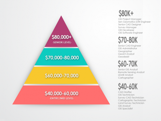
A visual of on GIS Analyst salaries from (from GISGeography.com):
Download ESGS WKU brochure here and click here for the finish in four year plan.
Graduate GIS Emphasis in the
Master of Science Degree in
Geoscience
(ref# 072)
For the M.Sc. in Geoscience, a minimum of 30 semester hours is required, with 12 semester hours in core courses and six hours of thesis. The GIS track focuses on the skills required in a variety of planning and government environments. Students have greater flexibility in this track to focus on a suite of courses that prepares them for employment in local and state planning, environmental management, government, consulting, and a myriad of other areas.
Download information on our graduate program here.
Past: GIScience Degree and Minor in GIS
B.Sc. Degree in Geographic Information Science (ref# 576)
Professional Degree in Geospatial Technologies and Information
NOTICE: After the Fall 2019 semester, the GIScience Degree (ref# 576) and GIS Minor (ref#
366) will no longer be offered. The B.Sc., Degree in GIScience (ref# 576) will become
a concentration in the new B.Sc., Degree in Geoscience along with the and the GIS Minor is being
eliminated. Geology and Geography/Environmental Studies will also be concentrations
in the new B.Sc., Degree in Geoscience. More details to come about the new bachelor's
degree in Geoscience. GIS (GISC) courses in both the GIScience Degree and GIS Minor
programs will continue to be offered after the Fall 2019 semester .
The B.Sc. GIScience program focuses on the concepts and principles of GISystems, along with its four components: (1) input, correction and collection of geospatial data; (2) storage and retrieval of geospatial data; (3) manipulation and analysis of geospatial data; and (4) maps and other forms of presentation of geospatial data. The professional major in GIScience requires a minimum of 54 semester hours. No minor is requiredfor this program, although students are highly encouraged to earn a minor (ref#) or take additional courses in Geography (ref# 374), Land Surveying (ref# 405), Geology (ref# 377), Computer Science (ref# 341), Computer Information Systems (ref# 347), or Earth Science (ref# 353); or students are highly encouraged to earn a Certificate in Land Surveying (ref# 1700) or an Information Systems Certificate (ref# 1714). For more information on minors offered by the Department of Geography and Geology, click here.
Land surveying provides GIScience majors opportunities in the GPS data collection business for the GIS and Land Surveying industries as well as management of that data with surveying, engineering and GIS firms. Geology and Earth Science favors GIScience majors with the oil and gas companies for implementing, utilizing, managing and/or creating an enterprise GIS whether it be for prospecting wells, managing utilities or analyzing geospatial data. Computer Science opens doors for GIScience majors to develop customized applications for GIS by furthering their GIS skills with deploying web mapping applications for use in mobile devices and smart phones. Students interested in GIS database management/Administration need to take Intro. to Database (CS 251). The hottest job market for GIScience majors on the higher end of salaries is GIS database administration. GIScience majors interested in this area would need to take two additional computer science courses in addition to the two required computer science courses. (CS 251's prerequisite is CS 181 Computer Science II. GIScience majors are required to take both CS 170 and either CS 180 or CS 270. (Please note that CS 270 will not count towards any CS program such as the CS minor.) For the GIS network infrastructure, Computer Information Science extends the GIScience degree skill set with an understanding and utilization of networking, centralizing and disseminating geospatial data within an organization that may extend beyond the traditional in-office desktop GIS software environment (e.g., facilities management, planning & zoning and transportation) with servers, mobile and wireless devices such as smart phones and GPS units.
Required Courses:
GEOG 103 (formally GEOG 100) or GEOL 111, GEOG 110, CS 170, GEOG 300, GISC 316 (or
GEOG 316), GISC 317 (or GEOG 317), GEOG 391, GISC 414 (or GEOG 414), GISC 417 (or
GEOG 417), GISC 418 (or GEOG 418), GISC 419 (or GEOG 419), GISC 443 (or GEOG 443),
GEOG 477 or GISC 423 (or GEOG 423), GEOG 475 or GEOG 495, GEOG 492, and GEOG 499. Required
Support Courses are CE 160/161, CS 180 (or CS 270), MATH 118 (or MATH 116 and MATH
117) and MATH 183.
GIS Minor (ref# 366)
NOTICE: After the Fall 2019 semester, the GIS Minor (ref# 366) will no longer be offered. Students are highly encouraged to pursue the Certificate in GIS (ref# 174).
This 26 (or 27) hour minor program provides a foundation in GIS. This minor is appropriate for students interested in careers utilizing GIS as a tool in such areas as archeology, biology, business, engineering, geography, geology, meteorology, social science, and public health, or for students pursuing a GIS as a profession in a related discipline such as Computer Science, Computer Information Systems, and Systems Management. Required courses (23 - 24 hours) include GEOG 103 (formally GEOG 100) or GEOL 111, GEOG 110, GISC 316, GISC 317, GISC 417, and GISC 419; and two additional course from the following GIS and/or geography courses: GISC 414, GISC 418, GISC 423, GISC 443, GEOG 477, or GEOG 492. Completing a minor in GIS also meets all requirements for earning an undergraduate Certificate in GIS.
Some of the links on this page may require additional software to view.